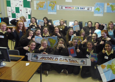
Ms Hennigan’s geography class giving a thumbs up for World GIS Day
Last November a ‘Missing Maps Mapathon’ took place in the Loreto Convent, Letterkenny which saw 25 3rd year students map vulnerable parts of the world to help international agencies, like the Red Cross, to better respond to humanitarian crisis and to reach vulnerable people quicker. This event was held to mark World GIS Day and the Loreto Convent were the only secondary school in Ireland to hold an event of its kind.
The students were rewarded for their efforts by securing first prize in a competition held by the Association of Geographic Information Northern Ireland (AGI NI), winning an iPad mini for their school.
This event was run by the Research & Policy Unit of Donegal County Council in conjunction with the Councils Social Inclusion Unit.
Twenty five 3rd year students from Ms Hennigan’s Geography class participated in the event and they were greatly assisted by Síofra Ní Fhearraigh, a transition year student who spent her work experience in the Councils Social Inclusion Unit. The ‘young mappers of the future’ digitally mapped urban areas in the Congo Region of Africa to help international agencies like the Red Cross and Medecines Sans Frontieres to respond better to humanitarian crises and to reach vulnerable people there quicker.
Ms Hennigan stated that “the Mapathon allowed me to see first hand how my students were learning about vulnerable parts of the world and through their work in making a difference there while also developing their own mapping skills. We look forward to hosting a Mapathon in Loreto Convent on an annual basis”.
Ms Hennigan’s class featured on the global map of all events taking place on World GIS day and were further rewarded for their efforts by securing first prize in a competition held by the Association of Geographic Information Northern Ireland (AGI NI), winning an iPad mini for their school, kindly sponsored by Irish Mapping & GIS Solutions (www.imgs.ie).
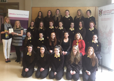
Ms Hennigan class being presented with the winning prize from the Association of Geographic Information along with staff members from Donegal County Council
Donegal County Council’s representative on the AGI, Rosita Mahony explained that “the Association of Geographic Information (AGI) is a voluntary organisation which aims to raise awareness of Geographical Information Systems (GIS) in order to make better decisions”. She congratulated Loreto Convent Letterkenny for their wonderful participation and application to the ‘Missing Maps Mapathon’ and thanked Irish Mapping and GIS Solutions for their prize sponsorship.
Simon Wheeler, Chair of AGINI said “The Missing Maps project is a fantastic project allowing everyone of all ages to make an active contribution to humanitarian relief. Without maps, the aid agencies cannot deliver help as effectively. It is also a great way for students to take an active interest in mapping and location data which can be an invaluable skill throughout their lives and we were delighted to be involved”.
As part of Geography Awareness Week which is celebrated globally from the 15th to the 21st of November, World GIS Day is a key event on the geographer’s calendar. World GIS Day first took place in 1999 as an international day for geographers to demonstrate real world applications that are making a difference and to educate young users of the benefits in using digital maps to make better decisions.
Select an option below